The Missouri offers plenty of day and overnight floats. During low water, islands and sandbars are great places to camp, fish or picnic. Some of the accesses marked are on the Missouri, bur others are up a tributary. The current in the tributaries slow as the rivers flow into the Missouri, which usually makes it easy to paddle a mile or two upstream. These upstream tributary accesses allow you more flexibility when planning a paddling trip. The conservation areas are marked so you can get out and explore along the way. For more information on Conservation Department areas along the river, write for the three free area brochures on the upper, middle and lower Missouri River.
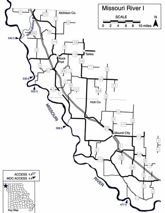
Missouri River I Mile by Mile Description
542.2 Nishnaborna River, left. Watson Access, 1.5 miles up Nishnabotna River.
530.6 Langdon Bend Access on left.
525.3 Hoot Owl Bend Access on left. Difficult canoe/kayak access due to high bank.
520.7 Deroin Bend Conservation Area, left, begins.
516.0 Deroin Bend CA ends.
510.0 H.F Thurnau Conservation Area, left, begins.
508.5 H.F Thurnau Access.
507.6 H.F Thurnau CA ends.
502.4 Rush Bottoms Conservation Area, left, begins.
499.8 Rush Bottoms CA ends.
486.3 Bob Brown Conservation Area, left, begins.
482.8 Bob Brown CA ends.
477.0 Payne Landing Access on left.
Missouri River II Mile by Mile Descriptions
477.0 Payne Landing Access on left.
463.0 Tom Brown Access on left. Poor canoe/kayak access.
462.1 Nodaway Island Access on left.
460.0 Worrhwine Island Conservarion Area, left, begins. Fair canoe/kayak access.
456.2 Worrhwine Island CA ends.
453.3 Sun bridge Hills Conservarion Area, left, begins.
452.3 Sunbridge Hills CA ends.
450.4 French Barrom Access (St. Joseph) on left.
451.6 Arrhur Dupree Memorial Conservation Area, right, begins.
449.8 Arthur Dupree Memorial CA ends.
437.2 Jentell Brees Access on left.
391.3 Platte River, left. Schimmel City Access, 2.8 miles up Platte River.
363.0 Riverfront Park Access.
352.6 La Benite Park.
351.6 Liberty Bend Conservation Area, right, begins.
350.6 Liberty Bend CA ends.

Missouri River III Mile by Mile Description
342.0 Cooley Lake Conservation Area, left, begins.
341.8 Cooley Lake CA ends. Private land begins.
341.6 Private land ends, and Cooley Lake CA begins.
341.5 Cooley Lake CA access.
340.6 Cooley Lake CA ends. Private land begins.
340.2 Cooley Lake CA begins.
339.8 Cooley Lake CA ends.
339.5 Fort Osage Access.
334.0 Fishing River, left. Pigg’s Landing Access, 3.8 miles up Fishing River.
272.0 Grand Pass Conservation Area, right, begins.
266.0 Grand Pass CA ends.
263.0 Miami Access on right.

Missouri River IV Mile by Mile Description
263.0 Miami Access on right.
250.0 Grand River, left. Brunswick Access, 3.4 miles up Grand River.
239.1 Dalton Bottoms Access on left. Canoe/kayak must be carried down moderately steep rip rap bank. 227.3 Chariton River, left. Lewis Mill Access, 1.7 miles up Chariton Rivet.
226.2 Stump Island Patk Access (Glasgow) on left.
195.4 Franklin Island Conservation Atea, left, begins.
195.2 Franklin Island CA access.
192.0 Franklin Island CA ends.
190.1 Diana Bend Conservation Area, left, begins.
189.4 Diana Bend CA ends, and private land begins.
188.8 Diana Bend CA begins.
186.5 Diana Bend CA ends.
185.1 Taylor’s Landing Access on right, just before 1-70 Bridge.
185.0 Overton Bottoms Conservation Area, right, begins.
183.5 Rocheport Cave Conservation Area, left, begins.
182.8 Rocheport Cave CA ends.
177.9 Overton Bottoms CA ends.
177.6 Eagle Bluffs Conservation Area, left, begins. No ramp, but can access river by carrying boat over riprap near parking lot.
172.6 Plowboy Bend Conservation Atea on tight.
170.7 Eagle Bluffs CA ends.
170.6 Perche Cteek, left. Providence Access, 1.4 miles up Perche Creek.
168.3 Plowboy Bend CA ends. Private land begins.
167.6 Plowboy Bend CA begins.
166.3 Plowboy Bend CA ends.
164.0 Marion Bottoms Conservation Atea, tight, begins.
159.8 Hamburg Access on left.
158.0 Marion Bottoms CA ends. Access on tight.

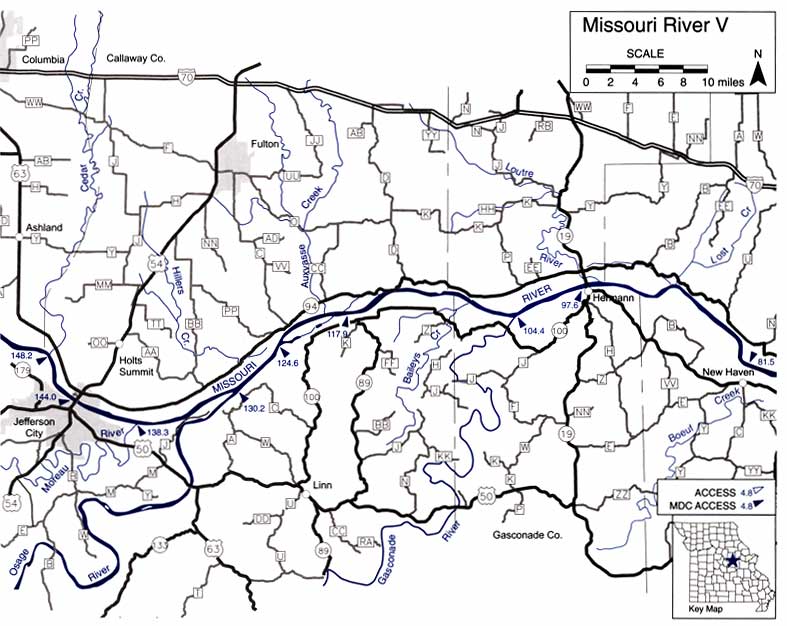
Missouri River V Mile by Mile Description
148.2 Cedar Creek, left. Capitol View Access, 0.5 miles up Cedar Creek.
144.0 Noren Access Jefferson City on left.
138.3 Moreau River on right. Moreau 50 Access, 1.7 miles up Moreau River.
135.8 Smokey Waters Conservation Area, right, begins.
134.4 Smokey Waters CA ends, and private land begins.
133.9 Smokey Waters CA begins.
132.5 Smokey Waters CA ends, and private land begins.
132.0 Smokey Waters CA begins.
130.3 Smokey Waters CA ends.
130.2 Osage River, right. Bonnots Mill Access, 1.9 miles up Osage River.
124.6 Mokane Access on left.
117.9 Chamois Access on right.
112.9 Tate Island Conservation Area, left, begins.
110.6 Tate Island CA ends.
104.4 Gasconade River, right. Gasconade Park Access, 0.5 1 miles up Gasconade River.
97.6 Hermann Riverfront Park Access (Hermann) on right.
96.8 Loutre River, left. Loutre Lick Access, 2.4 miles up Loutre River. Easy canoe/kayak access by carrying boat down short path to river.
81.5 New Haven Access (New Haven) on right.
Missouri River VI Mile by Mile Description
77.8 Boeuf Creek, right. Colter’s Landing Access, 1.4 miles up Boeuf Creek.
68.0 Washington City Access (Washington).
55.0 Weldon Spring Conservation Area, left, begins.
54.4 Weldon Spring CA ends, and private land begins.
53.5 Weldon Spring CA, left, begins.
52.2 Weldon Spring CA ends, and private land begins.
49.8 Howell Island Conservation Area, right, begins.
49.4 Weldon Spring CA, left, begins.
49.1 Weldon Springs CA access on left.
44.8 Howell Island CA ends on right.
44.3 Weldon Spring Conservation Area ends on left.
29.8 Louis H. Bangert Memorial Wildlife Area, left, begins.
29.6 Bangert WA ends.
29.6 River Woods Conservation Area, right, begins. Poor canoe/kayak access.
28.2 River Woods CA ends.
27.8 Blanchette Landing Access, left, begins.
27.5 Blanchette Landing Access ends.
23.6 St. Stanislaus County Park, right, begins.
22.5 St. Stanislaus County Park ends.
16.3 Pelican Island Natural Area. right, begins. Access to river possible at Sioux Passage Park, but have to carry canoes/kayaks along trail to river.
10.5 Pelican Island NA ends.
4.8 Columbia Bottom Conservation Area, right, begins.
3.5 Columbia Bottom CA access.
0.0 Mississippi River and end of Columbia Bottom CA.

This is an electronic reprint of a Missouri Department of Conservation document. More or updated information on this topic can be found at the Missouri Department of Conservation web site located at: mdc.mo.gov. Copyright 2003 by the Conservation Commission of the State of Missouri.
I am looking for float trip companions to float the Missouri River from Fort Benton, MT to St. Louis, MO about June 1, 2011 I can be reached at ([email protected])
i ahve 2 questions if i live in st.charles where is the best place to start and finish a float trip and if you suggest one how long mile wise