Most spring-fed of all the Ozark rivers, the Current may be floated at almost any time of the year, particularly below Welch Spring. On hot summer weekends, the river is usually crowded. Weekdays floats are much more peaceful. Due to the increase in size of the river and the frequency of motor boats below Big Spring, most canoe and kayak trips are made on the sections above Big Spring.
Find Camping and Canoe Rentals for the Current River
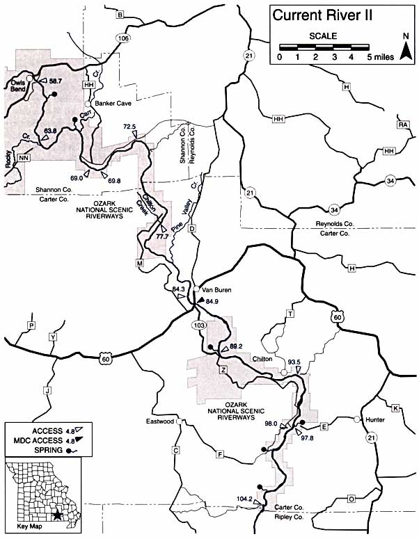
General River Information
Difficulty: I, occasionally II.
Gradients: general- 4.4; Montauk to Akers – 8.7; to junction of Jacks Fork – 5; to Big Spring – 3.8; to Doniphan – 3.2.
Counties: Dent, Shannon, Carter, Ripley.

58.7 Powder Mill, an old ferry site, with access and campground.
60.0 Blue Spring, ninth largest in the state, has deepest blue color. Reached by a 0.25 mile walk up its branch on the left.
63.8 Roberts Field access and campground. Rocky Creek enters on right. The Falls of Rocky Creek, 3 miles southwest of this point, are a scenic attraction of the area.
66.1 Spring on left.
66.6 Carr Creek and Cardareva Mountain on left.
69.0 Log Yard on left. Access and campground.
69.8 Beal Landing on left. Access.
72.5 Paint Rock Bluff.
77.7 Waymeyer Access on right at mouth of Chilton Creek, on County Road M-151 off Hwy. M.
81.5 Pine Valley Creek, also called Henpeck Creek, on left.
84.3 Watercress Spring Recreation Area. Forest Service and campground.
84.9 Van Buren Riverfront Park Access (Van Buren) and Hwy. 60 Bridge.
89.2 Big Spring. Access and campground. One of the largest springs in the world.
93.5 Clubhouse Landing. Access and campground, on County Road 60-221 offHwy. 60.
97.8 Hickory Landing. Access from Hwy. E at Hunter. Cave Spring-Jordan Spring Branch on left. Jordon Spring, 0.5 mile and Cave Spring, 1 mile up branch.
98.0 Catarac Landing on right. Access on County Road Z-217, off Hwy. Z and Hwy 103.
100.3 Panther Spring on right.
103.2 Bog Hollow. PhiHips Bay and Spring on right. Spring about 0.25 mile from river.
104.2 Gooseneck campground on right. Access on Farm Road 3142-County Road CI0, off Hwy. C.
104.2 Gooseneck campground on right. Access on Farm Road 3142-Counry Road C10, offHwy. C.
105.8 Forest Service campground on left. Bagamaw Bay on right. Limited access road.
107.7 Big Barren Creek on right. Twin Springs 0.75 mile up creek.
110.5 Cedar Creek on left. Forest Service campsite in this area.
112.8 Buffalo Creek on right.
113.0 Compton Camp. Forest Service campsite, on right.
118.8 Deer Leap Recreation Area. Forest Service access on left.
119.3 Float Camp Recreation Area. Forest Service access on left.
120.3 Dun Roven unimproved access on right.
123.8 Hwy. 160 Bridge.
124.0 T.L. Wright Memorial Access (Doniphan) on right. Private campground nearby. Stores, meals, lodging in Doniphan.
129.8 Big Island.
135.0 Goose Lake, a lake-like pool of the river.
136.3 Missouri-Arkansas state line.
138.0 Current View. Private access.

This is an electronic reprint of a Missouri Department of Conservation document. More or updated information on this topic can be found at the Missouri Department of Conservation web site located at: mdc.mo.gov. Copyright 2003 by the Conservation Commission of the State of Missouri.