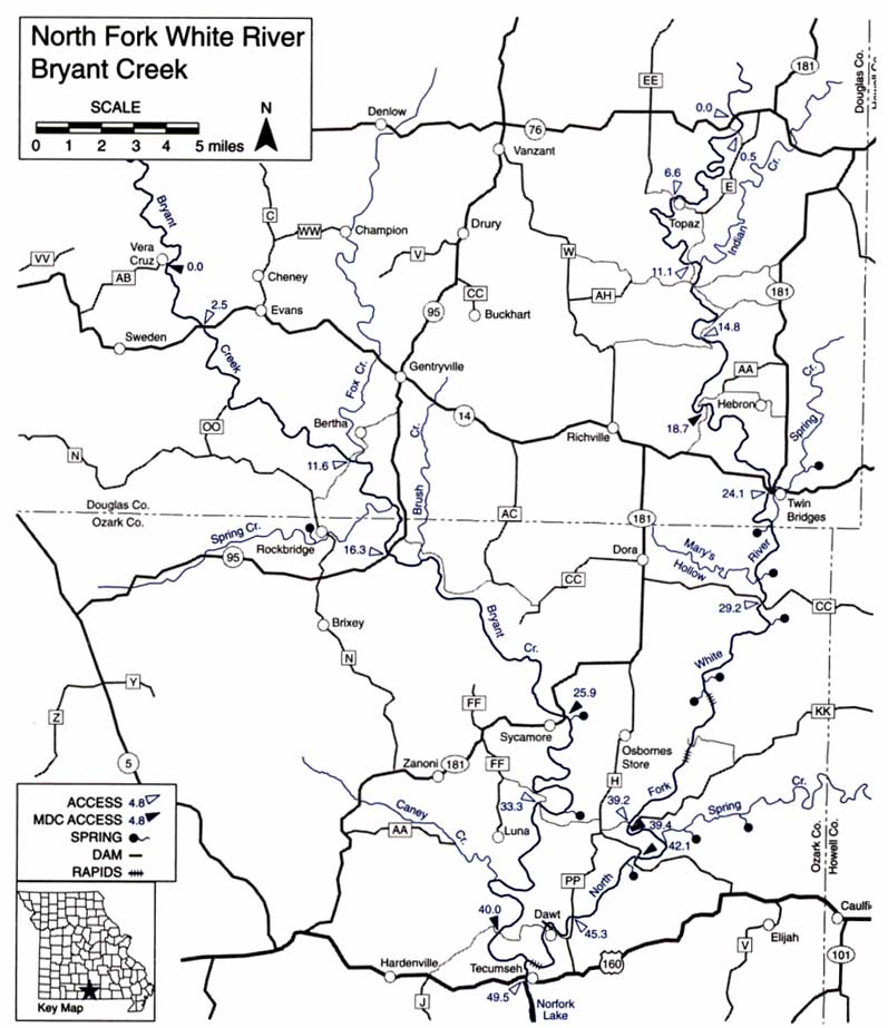
Bryant Creek is a relatively wild stream, provides only slightly less paddling mileage than the North Fork, and is highly fishable. Less spring fed, it has less volume than the North Fork and is more difficult to float because it is narrower and has more obstacles, but it also has some fast riffles. Local inquiry or examination should be made to determine whether the sections above Hodgson Mill Spring are floatable in summer without wading riffles.
Difficulty: I and II.
Gradients: general- 5.8; Hwy. 14 to Bertha Ford – 7.8; to Hodgson Mill- 5.3; to Tecumseh – 5.0.
Counties: Douglas, Ozark.
Bryant Creek – Mile-By-Mile Description
0.0 Vera Cruz Access on Hwy. AB. Moderately difficult access for canoes/kayaks.
2.5 Hwy. 14. Access.
4.0 Rippee Conservation Area on left.
6.3 Monastery Bridge, off Hwy. OO. May need to portage or walk boats. Check.
11.6 Bertha Ford low-water bridge access, on County Road N-345 off N and County Road 95-345 off Hwy. 95. May need to portage or walk boats. Check.
11.9 Fox Creek on left has considerable drainage area and the five miles below Hwy. 14 have a gradient of 13, but the creek is seldom runable.
14.4 Spring Creek on right. Three miles up the creek, there is a small community known as Rockbridge which has a spring, fish hatchery, mill and store. Rockbridge is best reached from the Bertha Ford, off Hwy. N. L
16.3 Hwy. 95 low-water bridge and Bell School. Access.
17.5 Brush Creek on left. A fair road on the left bank parallels the creek for about 1.3 miles below here.
24.0 Private campground on right.
25.9 Hwy. 181 low-water bridge at Aid-Hodgson Mill. Sycamore Access on right below bridge. Gravel ramp. Until a few years ago, this water mill was still in operation. Its stone buhr ground flours, which are now ground at a modern factory in Gainesville, are sent throughout the nation. The spring, which furnished water power for the mill, has an average daily flow of 24 million gallons and has been ranked as 15th in size in the state. The eight-mile section of the creek above here is excellent fly-fishing water.
29.4 North side of The Narrows. It is two miles around Muleshoe Bend from this point, but only 0.2 mile as the crow flies. The next bend in the river is wider and is known as Horseshoe Bend.
32.3 Brixey Spring on left. The spring is often obscured by willows, but its branch is easily seen where it enters the creek.
33.3 Warren Bridge low-water access. Road connects Hwys. FF and H. Excellent swimming hole below the bridge.
37.5 Caney Creek on right.
40.0 Florence C. Cook Access on right, on County Road 308, off Hwy. 160. Dirt ramp.
42.6 Junction with North Fork. Next access 0.4 mile downstream. Don’t miss the last rift, just above this access. See North Fork for description.